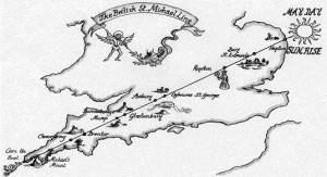
This is a ley line:
This particular one is the St Michael’s ley line. It’s an imaginary dot-to-dot across southern Britain, connecting various pre-historic and medieval monuments,.
Ley lines were first proposed in 1921 as an archaeological theory. Albert Watkins suggested that in an earlier age, when this country was covered in forest, there were a few straight tracks that crossed the island from coast to coast. Important sites of pilgrimage were therefore built close to the tracks. His idea did not catch on with other archaeologists. They pointed out that, given the large number of historical landmarks littering the map of Britain, almost any straight line you draw across it is bound to hit a few.
Nevertheless, since the 60s a New Age mythology has been built up around the lines. Writers have claimed ley lines are natural sources of ‘vital energy’, that they having healing properties, that they are somehow linked with feng shui, ancient astronomy, or the Nazca lines of the ancient Peruvians.
Here’s an article on ley lines as part of an ‘earth matrix’. There’s a lot of information in that article and I wouldn’t beat yourself up if some of it didn’t make sense to you. But while we might all enjoy a smug laugh at the mystics, I can’t deny that there’s something seductive about looking at a map and seeing, buried underneath the motorways and rivers and other lines carving up our island, evidence of an ancient order totally different to our own.
Well, recently I found something that gives me that feeling. This is the Atlas of true names. It shows the original names of towns and cities, translated from old English, Gaelic and Danish. These names evoke images of what familiar places may have looked like a thousand or so years ago- when Hampshire was an ‘enclosed settlement’, and Scotland the ‘land of darkness’.
Take a good look at this map, and you start to picture a densely wooded island filled with separate peoples living in fortress communities named after their leaders- the Red One, the Short one, the Hasty one- it might help you to translate those town names if you bear in mind that in Old English ‘ing’ meant something like ‘the people of’. Also, good to know there was a whole town of people living ‘on the edge’. So they weren’t so different from us alter all.
And there’s so many mysteries in those names. How much more tattooed were our ancestors than their neighbours? Just what went on at the sinister-sounding ‘Important Place on the Remote Farms’? At what point did London change from being unfordable to unaffordable?
It’s refreshing to look at this island of concrete and gardens and see a wilderness. It is a world that has now been entirely abolished, and even in the remotest corners of Britain you can only catch a glimpse of what that world might have been like. But it’s good to remind yourself how recently, in fact, this land was cleared and tarmacked over. On the scale of human history, it was not so long ago that we moved from farms and fortresses to subways and skyscrapers. We’re still using the names of Saxon chieftains to guide us from one service station to the next. There is a long and rich history to this island, and you’re living in a particularly strange and tumultuous part of it.


